
Overview
A C3 system, which stands for Command, Control, and Communications, is a fundamental tool for all disaster and safety operations. These systems deliver critical information needed to plan, coordinate, and control teams and operations during a full range of emergency missions, including those in extreme weather conditions. A C3 system is designed to be flexible and can be deployed for any kind of incident, from minor train crashes to extreme natural disasters.
A C3 system integrates facilities, equipment, personnel, procedures, and communications into a common organizational structure. This allows for a coordinated response among various public and private agencies and jurisdictions. It also establishes common processes for planning and managing resources.
Protecting the Environment
A C3 system can be used to protect the environment in a variety of ways, including:
- Managing catastrophic events and disasters
- Responding to environmental law offenses
- Monitoring pollution
- Providing real-time monitoring and early warnings
- Managing human and equipment resources
- Managing remote sensors and data acquisition
- Facilitating departmental interactivity
- Supporting a Decision Support System
- Alerting citizens
The Disaster-Management Cycle
A C3 system supports the key stages of the disaster-management cycle:
- Prevention: Being proactive is the best way to address a disaster.
- Mitigation: The goal of mitigation is to minimize the loss of human life that would result from a disaster.
- Preparedness: Have processes ready at all times for command, control, and communication.
- Response: Have the necessary means, data, and decision-making processes ready at any moment.
- Recovery: Have human resources well-organized.
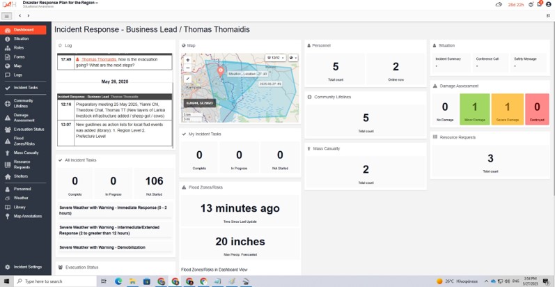
C3 System Components: The Control Room
Monitoring and sharing a constantly expanding volume of video and data is essential for effective collaboration in a control room. Control rooms use various communication technologies to capture, extend, stream, display, record, switch, and manage content for effective decision-making. A control room must connect to all available communication links, including wireless networks, radio communications, land-wired communications, and satellite communications.
A control room setup may include a 3×2 video wall, an interactive board for debriefing, and work stations. There can be separate desks for dispatchers and data operators, as well as for consolidated stakeholders.
Mobile Units and Sensors
C3 systems can utilize mobile units, such as a 4×4 pickup truck, that are customized with specific equipment. This customization can include a tethered drone, a customized equipment cabin, a dual-camera EO/IR system with a laser distance measurement, and a ruggedized control station with the C2 application. The mobile unit also includes communication systems with an LTE router, VHF/UHF radio with IP push capability, and an optional satellite communication station. Other features can be a Dash Camera, a telemedicine station, a LoRa receiver for nearby sensor systems, a GPS locator, and an air quality monitor.
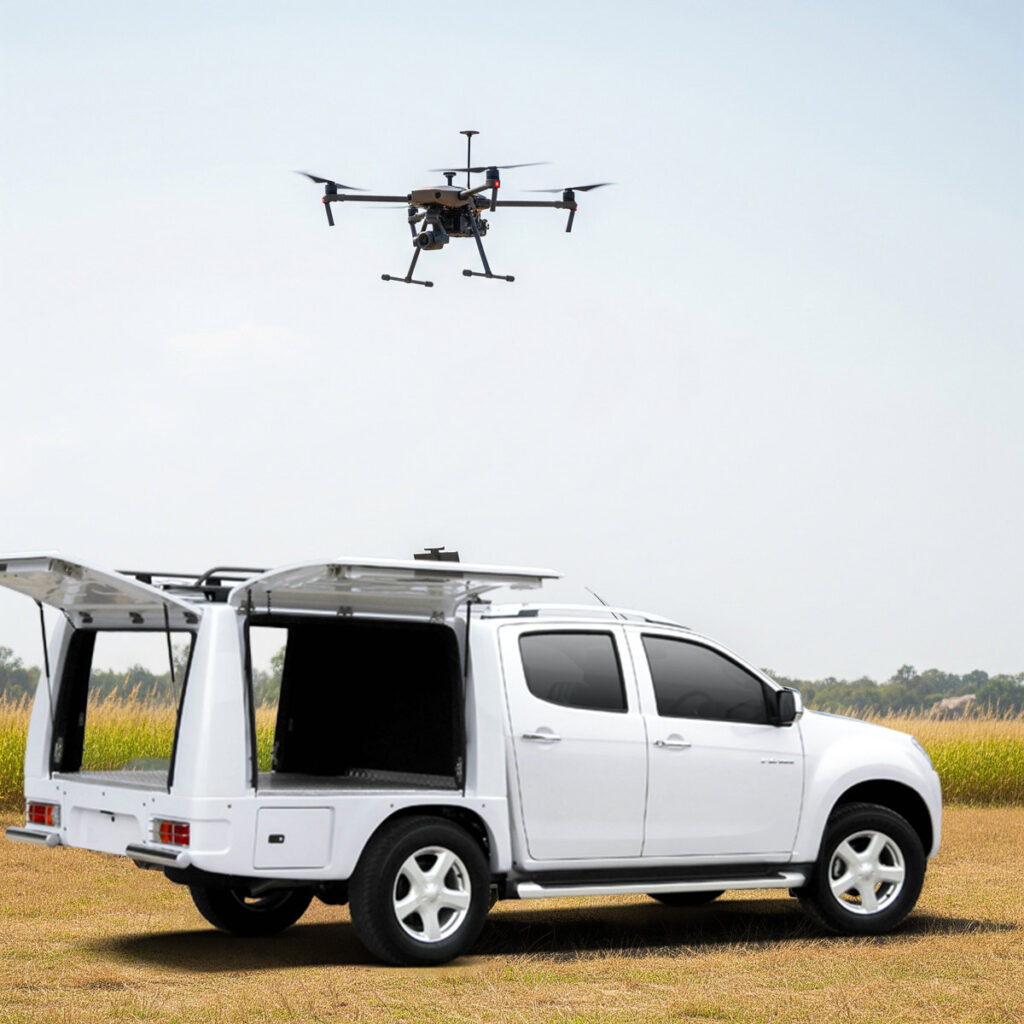
The mobile unit’s drone can take off and land from the vehicle without the crew having to move from it. It can receive secure commands and transmit high-definition video to a Ground Control Station (GCS) via a tether cable or wirelessly. It can operate at an altitude of at least 100 meters. The drone has GNSS (at least GPS and Galileo) and can operate for a minimum of 24 consecutive hours at its Maximum Take-Off Weight (MTOW).
The drone can carry a dual sensor payload, including an optical and an IR camera, with a laser rangefinder. This allows for the automated identification of fire or smoke sources and real-time image transmission. The optical camera has a resolution of at least 1920x1080p, with a minimum of X30 optical zoom and X4 digital zoom.
The C3 Application Platform
The C3 application platform offers capabilities for environmental monitoring, event monitoring, crisis management, and coordination. It enhances the effectiveness of civil monitoring and protection planning and provides critical insights for every phase of an incident. The platform facilitates:
- Coordination of agencies: It provides a single platform for data exchange, reporting, and real-time communication.
- Evaluation and assessment: It integrates systems for analyzing exercises and generating performance reports.
- Event and offense recording: It offers tools to record events, environmental law offenses, identify risks, and create customized response scenarios with all related documentation.
- Data logging: It provides real-time information about an incident.
- Resource management: It identifies available units and equipment for administrative, on-site, civil, rescue, or recovery actions.
- Team communication: It facilitates communication between teams from different agencies.
- Scenarios and forecasting: It visualizes event spread and risk based on data.
- Operational response: It organizes response teams and logs actions.
- Post-crisis reports: It allows for the evaluation of operations for future improvement.
- Damage assessment: It provides immediate reporting of high-risk areas.
- First response coordination: It allocates resources to critical areas.
- Camp management: It monitors human and animal evacuations and provides humanitarian aid.
The platform also includes GIS Mapping features, such as high-quality base maps, data visualization with clusters, and the ability to add annotations and image overlays for real-time incident planning. It supports adding custom maps and layers, visualizing incidents like hazard zones, and exporting map data for use in other GIS systems.
Communication and Data Sharing
The C3 application platform offers a variety of communication and data sharing features:
- Connections via public links: It allows for sharing real-time incident information with external organizations or partners through secure public links.
- Sharing via email: Data and updates can be shared directly with internal or external stakeholders via the platform’s email system.
- Exports to PDF: All incident data can be exported into professional PDF documents for archiving or further use.
- Extension Packs: The platform includes extension packs with predefined templates for specific industries or incident types.
- Interaction Tools: It supports interactive collaboration through real-time logs, dashboards, and status boards.
- SMS alerts: Alerts can be sent directly to internal or external stakeholder groups via a local mobile network.
- Report and Analysis Integration: Incident data can be sent to analytics tools like Tableau or Power BI. PDF or CSV files can also be exported and uploaded to other databases.
- Multi-Channel Alerting Support: It can send messages and notifications via SMS, email, or other channels and integrates with mass notification systems.
- API for custom integrations: It allows for real-time data exchange and integration with other platforms, such as GIS, CRM, and reporting tools.
- Webhooks: It can send updates and notifications to other platforms and automatically trigger actions when an incident is updated.